Tag Archives: region of waterloo

Regional Budget 2019: time for some bus love

On Tuesday, councillors will be finalizing the 2019 Region of Waterloo budget. Unfortunately, proposed transit improvements, vital to Grand River Transit’s growth, are under potential threat, as councillors seek to trim costs.

This year’s proposed transit improvements include a new 206 Coronation iXpress route connecting Fairway, Preston, and Galt, as well as a bunch of improvements and route changes that would help equalize the level of transit service in Cambridge with that of Kitchener and Waterloo. It’s a vital part of the already watered-down GRT business plan, and an important precursor to ION phase 2.

Unfortunately, the Region’s online budget survey, dominated by non-transit riders,  showed low levels of support for these improvements. Councillors reading the survey results might think they have political cover for cutting planned transit service from the budget.

We can’t afford to let that happen.

Please take a few minutes to send an email to your regional councillors in support of the transit improvements in the budget. A strong expression of support will go a long way in ensuring our community continues to invest in equitable and sustainable transportation.

Other important measures in the proposed budget include the hiring of a planning engineer who will help coordinate active transportation projects and a bus pass program for Conestoga College students.

Read More »

pexels-photo-186408

Week in review: October 22, 2016

Regional Budget

It’s time for the Region to start preparing next year’s budget again. Assessments are down, which means less natural revenue growth. The projected property tax increase to cover planned or anticipated expenses is about 4%.

At risk is the GRT business plan, which calls for increasing bus service by nearly 30% over the next five years. This is necessary in order to integrate GRT buses with ION light rail service and grow ridership by 40%. This will be a challenging task, one not made easier by the fact that ridership has fallen in the face of years of punishing fare hikes. Will Regional Council have the vision to continue to invest in transit in Waterloo Region, without gouging transit riders?  (more…)

Read More »

photo-1468742886740-1ad3f553ff53

How long should you have to wait for the bus?

Imagine a gate at the end of your driveway that opens only once every 30 minutes. How would that affect you?

We tend to think of trips by car in terms of how much time they will take. So it’s natural to compare transit by the same yardstick. How long will this trip take by bus compared to car? Is a train that takes 44 minutes to travel 18km fast enough? No question: fast transit is good.

But frequent transit is better. Frequent transit means being able to travel when we want. But this is often overlooked. It may even be overlooked in the next GRT business plan. But more on that in a moment. (more…)

Read More »

ixpressmap

What’s in store for Grand River Transit?

What’s in store for GRT? As we prepare for the arrival of ION, the region’s Transit Services has given us a glimpse into the next few years of Grand River Transit. Here  at TriTAG, there’s nothing we like more than a thick PDF full of juicy planning details. We dive into the Interim Report on GRT’s 2017-2021 business plan so you don’t have to!

Obviously, ION’s launch in early 2018 represents a major change for our region. With ION light rail providing a fast, reliable backbone for transit trips across a single fare, integrated transit network, the bus system needs some changes to take advantage of this. In addition, plans are afoot to continue growing the iXpress bus network:

  • New 205 Ottawa iXpress (Sept 2017)
  • 10 minute peak frequency on 201 and 202 (Sept 2017)
  • Extension of 201 to Block Line ION (early 2018) and then on to Conestoga College (late 2018)

You should expect to see some major changes to other bus routes in the wake of ION, as well:

Also look for service frequency improvements a number of routes, as well as possible expansion to serve new suburbs and some townships.

Some of the changes proposed by GRT for 2017.

Some of the changes proposed by GRT for 2017.

Underlying all of this is a strong growth target being set. After over a decade of skyrocketing ridership, 2014 and 2015 saw a decrease in the number of riders. Planners blame this on a loss of school board funded high school trips, the disruption of ION construction, and also on years of unrelenting fare increases that GRT has been directed to undertake.

However, region staff expect ridership growth to bounce back and then some. Serving just under 20 million rides a year right now, the plan is to reach 28 million in just 5 years!

This will take some doing. For one, ION will need to live up to its expectations. But the real question is whether our regional council is ready to make the investment in transit that this requires. This means committing to funding the expanded service hours (29% over 5 years) and to stop driving away riders– in particular, the new riders GRT seeks– with continuous fare hikes well above inflation.

Regional government must commit to supporting ridership growth to hit these projections.

Regional government must commit to supporting ridership growth to hit these projections.

There’s more in this report that catches our eye, but only so much we can go into in one post. Do the proposed route restructures make sense? Is GRT being too cautious and incremental in its redesign to meet lofty ridership goals? And is there an overemphasis on peak service frequency at the expense of all day flexibility?

We’d like to delve deeper into these questions. Watch this space.

Upcoming consultations on the GRT business plan:

Thursday, September 22, 2016 
Drop in anytime between 5 – 8 p.m.
Lions Arena
20 Rittenhouse Road, Kitchener
GRT Routes 3, 12, 22 and 201 iXpress

Thursday, September 29, 2016
Drop in anytime between 5 – 8 p.m.
Waterloo Memorial Recreation Centre,
2nd Floor, Hauser Haus
101 Father David Bauer Drive, Waterloo
GRT Routes 5, 8, 12 and 200 iXpress

Read More »

22107845363_7b3fccf843_k

Shifting gears for climate in Waterloo Region

TriTAG sees itself as an organization focused on transportation issues. That’s not to say that we don’t have concern for environmental issues, but that we look at a wide range of benefits from improvements to how we get around, not just environmental – we’re also motivated by the impact transportation has on quality of life, public health, safety, social justice, economic growth, government spending, and even civic engagement.

All that said, we acknowledge the reality of global climate change, and our responsibility as a community to respond to it. World leaders have just adopted an agreement that will require sustained reductions in carbon emissions. Changes in transportation will play a role in how emissions are reduced, and walking, cycling, and transit can and should play a large role in that.

Transportation in Waterloo Region accounted for 1,467,858 tonnes of carbon emissions in 2010, or 40% of the Region’s total. The Regional Transportation Master Plan is anticipated to bring about 75,000 tonnes of emission reductions by the end of 2020, through the introduction of ION light rail and more iXpress bus routes. These changes are expected to increase transit ridership from about 5-6% today to 15-17% by 2031.

By comparison, the Region’s targets when it comes to active transportation are far more modest. (Even ‘wimpy’, according to the Easy Riders Cycling Club.) If the Region’s targets are met, it would only increase cycling mode share from 1% to 3% by 2031. From a climate perspective, this sort of change barely registers.

But cycling could play a much greater role in reducing emissions in Waterloo Region. A poll of Ontario residents last year showed that 67% would cycle more if their community had more and better cycling infrastructure. (more…)

Read More »

Photo (c) 2010 James Schwartz on Flickr, licensed under CC-BY-ND.

Signs, signs, everywhere a sign

Regional staff think they can reduce bike crashes with ‘cyclist dismount’ signs. Provincial guidelines say that’s a bad idea.

It’s no surprise that over half of all collisions between bikes and cars take place in crosswalks. It’s partly why our local municipalities have opted to prohibit sidewalk cycling in their bylaws.

Some might argue it’s the victim’s own fault if they’re struck while biking in a crosswalk, as they’re willfully breaking the rules of the road. But when it comes to other issues of public health, such as smoking, substance abuse, or even sedentary lifestyles and poor diets, we don’t allow a person’s choices to prevent us from trying to protect them from unnecessary illness, injury, or death.

Preventing traffic violence should be no different.  In fact, traffic engineers recognize that they can’t just expect drivers to perfectly follow speed limits or obey signs to protect themselves, but have to apply good design and analysis to protect drivers from their own mistakes, (not to mention their passengers or others on the road). This may involve changing the environment so that mistakes are less deadly, or changing the factors which influence people to make those mistakes in the first place.

Each year as part of the Region’s collision report, the top locations for crashes are determined for people driving, walking, and biking, and countermeasures are considered to try to reduce frequently encountered types of collisions. For top collision locations for cars, changes  including conversions to roundabouts, addition of left turn lanes, and dedicated turning phases are considered. For many of the top locations where people walking are struck, better lighting, countdown timers, more visible markings, and crosswalk relocation are all on the table. For King and Cedar, where several people biking with the sharrows have been struck by turning cars, staff are considering restricting certain turns.

Cyclist dismount sign

This sign is used to tell people biking to dismount and walk, which the Ontario Traffic Manual discourages. Photo (C) 2011 Richard Masoner on Flickr, licensed under CC-BY-SA.

But when it comes to people getting hit by cars while biking in crosswalks, it seems the best staff think they can do is put up a bunch of ‘cyclist dismount’ signs.

The province’s bicycle facility guidelines discourage installing ‘dismount’ signs because they aren’t frequently obeyed, and worse, can influence people to ignore other signs and signals:

“The option of asking cyclists to dismount and walk their bikes should not be relied upon in lieu of adequately accommodating cyclists through appropriate road design. Being propelled by muscular power, cyclists more than other vehicle operators will prefer to sustain their momentum and avoid stopping. Cyclists usually find it difficult to rationalize why “dismount and walk” restrictions are in place, and conclude that they were a poor, illogical or arbitrary decision. Thus, if facility designs cause cyclists to make what they consider to be unnecessary stops, this will increase the likelihood that they will ignore or disobey traffic controls, which breeds disrespect for these devices.”

Ontario Traffic Manual Book 18, 1.5 Cycling Myths, page 9

There are several other important reasons why putting up dismount signs aren’t a great idea:

  1. It ignores the real source of the problem. Many of these collision locations are terrible places to bike, leading many to conclude that it’s safer for them to use the sidewalk than the road. Protected bike lanes along these roads, coupled with good intersection design would go a long way towards improving safety.
  2. It implies cycling on the sidewalk is otherwise acceptable.  Putting up signs for cyclists who are on sidewalks would suggest they are expected to be there, which isn’t the case. Even if people biking obeyed the signs and walked their bikes, there would still be conflicts between people walking and biking on sidewalks.
  3. It’s not a viable solution for when sidewalks are changed to multi-use trails. The Region is increasingly looking to using wider multi-use trails in place of sidewalks and bike lanes on busy roads with no driveways. One of the top collision locations, Ottawa at the Laurentian Power Centre entrance, is expected to get multi-use paths sometime around 2020. If we are going to build pathways along roads, we need to design intersections to accommodate people who bike, not effectively ignore them.

Sometimes, paying attention to the actual factors that change behaviour and influence collisions is hard, and putting up signs can make us feel like we’re doing something. Preventing people from being struck by cars in crosswalks requires more than just tsk-tsking them for not dismounting from their bikes, but appropriate infrastructure with good design to accommodate them. We hope to find better solutions in future collision reports.

Headline photo (C) 2010 James Schwartz on Flickr, licensed under CC-BY-ND 2.0.

Read More »

An alternative design for University Avenue

In our last post, we raised some concerns with the Region’s recommended design for the reconstruction of University Avenue between Erb Street and Keats Way.  In particular we have issues with the inadequate separation from motor traffic, and the ability to maintain the lanes in winter.  Here is a quick overview of a design that we believe better addresses these issues.

Illustrated below is the Region’s recommended design.  It features 1.5m bicycle lanes separated from motor traffic by 0.6m buffers.  It also includes sidewalks on both sides of the street – there is currently only a sidewalk on the east side.

University Ave - Erb St to Keats Way, ROW proposal, looking northeast

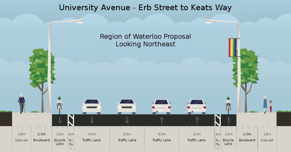
Region of Waterloo staff recommended design alternative for University Ave

To address our concerns regarding bicycle-car separation and winter maintenance, we would prefer that the bicycle lanes be moved off the main roadway.  Illustrated below is a road layout that takes up the same space as the region’s proposal but provides bicycle paths separate from the main roadway.

Improved University Ave - Erb St to Keats Way, looking northeast

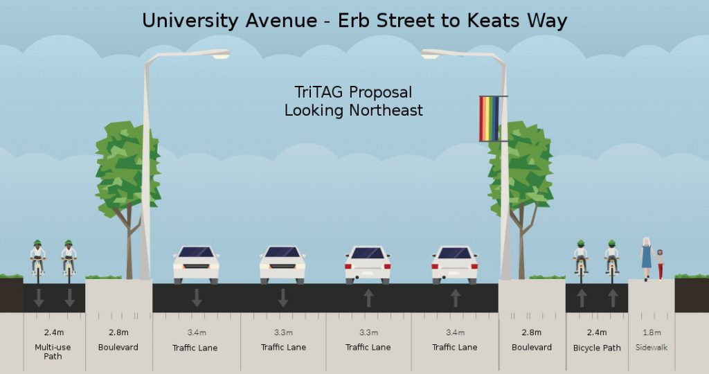
Improved design alternative for University Ave with separated bicycle paths

This arrangement replaces the two one-way bicycle lanes with two one-way bicycle paths.  This type of infrastructure is common in the Netherlands, where it is allows people of all ages and abilities to cycle to their destinations even along fast and busy roads.

In this arrangement, the boulevard forms the buffer between bicycles and cars, freeing up the space from the two 0.6m painted buffers to be used for other purposes, such as widening the bicycle path.  It is important to note that off-street bicycle paths need to be wider than painted lanes, since cyclists do not have the option to leave the lane to overtake a slower cyclist.

Unlike in the region’s plan, we do not propose to add a new sidewalk on the west side of the road.  There is no access to the properties on the west side, and there are few origin-destination pairs that would make for a competitive walking trip.  As a result, the potential volume of pedestrian traffic would be minimal.

With so few pedestrians, it’s hard to justify building and maintaining separate pathways for pedestrians and cyclists.  The handful pedestrians that would walk along the west side of the road would not be inconvenienced by walking on the bicycle path, nor would cyclists be inconvenienced by such a small number of pedestrians on the bicycle path as long as it is sufficiently wide.

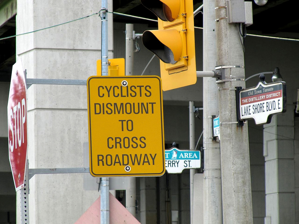
To complement this shared arrangement, there needs to be thoughtful intersection design.  The current standard designs for multi-use paths where the path ends at intersections and cyclists are expected to dismount are not acceptable. Fortunately, there are good examples of how to integrate off-road bikeways with intersections.

Omitting the west sidewalk saves 1.8 metres in the first improved design alternative, which can be allocated instead to widening the boulevard and the bicycle paths.  But this is not a critical component of the design.  There could be sidewalks on both sides, or on neither side, and the effect would be generally the same.

The end result of this design would be to make cycling along this segment of University Avenue an attractive option for people of all ages and all levels of interest in cycling.  While the remainder of University Avenue will remain hostile for now, we urge the Region to use this project as a first instance of a new standard of cycling infrastructure for arterial roads that is safe and comfortable enough for everyone.

Read More »

university

Could University Ave slip through the cracks?

On Tuesday, Regional staff will be presenting a report to the Planning and Works Committee, recommending the widening of University Ave between Erb St and Keats Way from 2 lanes to 4, and the addition of a new sidewalk to the west side where none currently exists. However, while staff had considered some sort of protected bike lanes or cycle tracks, the report rejects them in favour of on-street bike lanes with a narrow buffer.

While these on-road buffered bike lanes offer slightly more separation than the existing lanes, and are similar to ones we have supported for Westheights Drive, the context of University Ave makes them less appropriate. University has a speed limit of 60 km/h (which means speeds are typically higher), and sees four times as much traffic during the day. Based on these characteristics, the Ministry of Transportation’s guidelines on bicycle facility design strongly recommends considering segregated bike lanes, cycle tracks, or in-boulevard facilities. The lack of intersections and driveways also makes this block a prime candidate for protected bike lanes or boulevard multi-use pathways (which are less expensive than widened roadways and sidewalks).

So why are staff recommending on-street lanes? The report states that,

“University Ave. both north and south of the project currently has on road bike lanes and it makes the most sense for this portion of University Ave to maintain an on-road bike lane for continuity with the adjoining sections.”

At WaterlooBikes, Narayan Donaldson calls this  justification “the most absurd I have ever seen in a Canadian traffic engineering report.” Basically, we can’t do much to improve the cycling facilities on this section of University Ave, because we have lousy cycling infrastructure at either end – infrastructure where Tiberiu David was struck from behind and killed while riding his bike in 2010.

Donaldson goes on to give examples of where fully protected cycling facilities have been successfully transitioned with on-street lanes, demonstrating that integrating on-street lanes with fully protected facilities is in fact possible.

Why do recommendations like these happen?

Because no one’s paying attention. 

The report notes that only three people attended the public consultation back in November. As much as we like to think we have a Regional government that somewhat ‘gets’ the need for good active transportation infrastructure, as with any large organization, change really only occurs when people stand up and demand it. It’s plausible that after the poor attendance, the staff responsible may have concluded residents didn’t consider this stretch of road to be all that important, despite whatever latent demand may exist.

The Region itself may no longer have the staff resources to keep an “eye on the ball” for active transportation projects like this either. The planner and engineer responsible for developing the Active Transportation Master Plan, along with both Transportation Demand Management planners have either transferred to different departments or to other municipalities, and to our knowledge, none of these roles have been replaced. This void may also be the reason why the Active Transportation Advisory Committee has not been consulted on this project. We hope that as the Region establishes its priorities for this Council term, it will ensure that it has the people it needs to oversee the successful implementation of the ATMP.

The good news is that there’s still a short window of opportunity to change the course of the University Ave project, as Regional Council has yet to vote on the recommendation. Why not reach out to your councillors, or speak up at Tuesday’s committee meeting, and let them know you’re paying attention, and hope they will too.

Read More »

northfield

A brief look at the new Northfield multi-use path

Northfield Drive East has a new multi-use path. The stretch between Wissler and Bridge previously was just a two-lane road with unpaved shoulders and no sidewalks or bike lanes. It was supposed to be widened this year to four lanes, with a sidewalk on one side, and a multi-use path on the other, but this work was deferred until work on the Northfield Highway 85 overpass could be completed, to avoid disrupting too much traffic all at once.

Because of this delay, the Region decided that allowing for active transportation on this road simply couldn’t wait. It has now paved the one shoulder to form this path on the south side of the road. It’s a creative and inexpensive solution to a significant gap in the active transportation network, while providing a significant level of protection to those on the path. (more…)

Read More »