A profile of a human-friendly Uptown
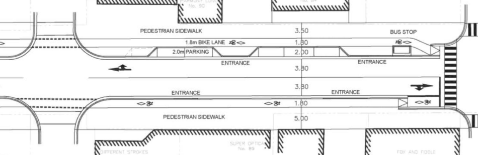
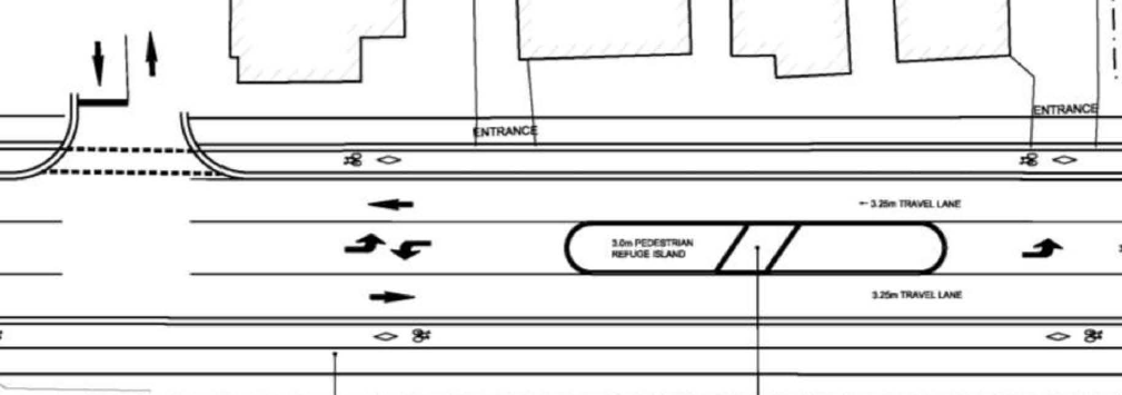
Hopefully, by now you’ve had a chance to see the new proposal for Uptown Waterloo’s new streetscape, and how King St. could be reshaped all the way from Erb up to University. If you haven’t, go ahead and take a look at the public information boards presented last Thursday. You can also read more about the project’s evolution here.
This proposal needs your support. Please provide your feedback on the Uptown Streetscape project by email to Barb Magee Turner (barb.mageeturner@waterloo.ca) and Eric Saunderson (esaunderson@regionofwaterloo.ca) by Thursday June 12th! Tell them what you like about it, how you see yourself using it, and any suggestions for further improvement. NEW: Write to the project managers and members of council with our easy contact form.
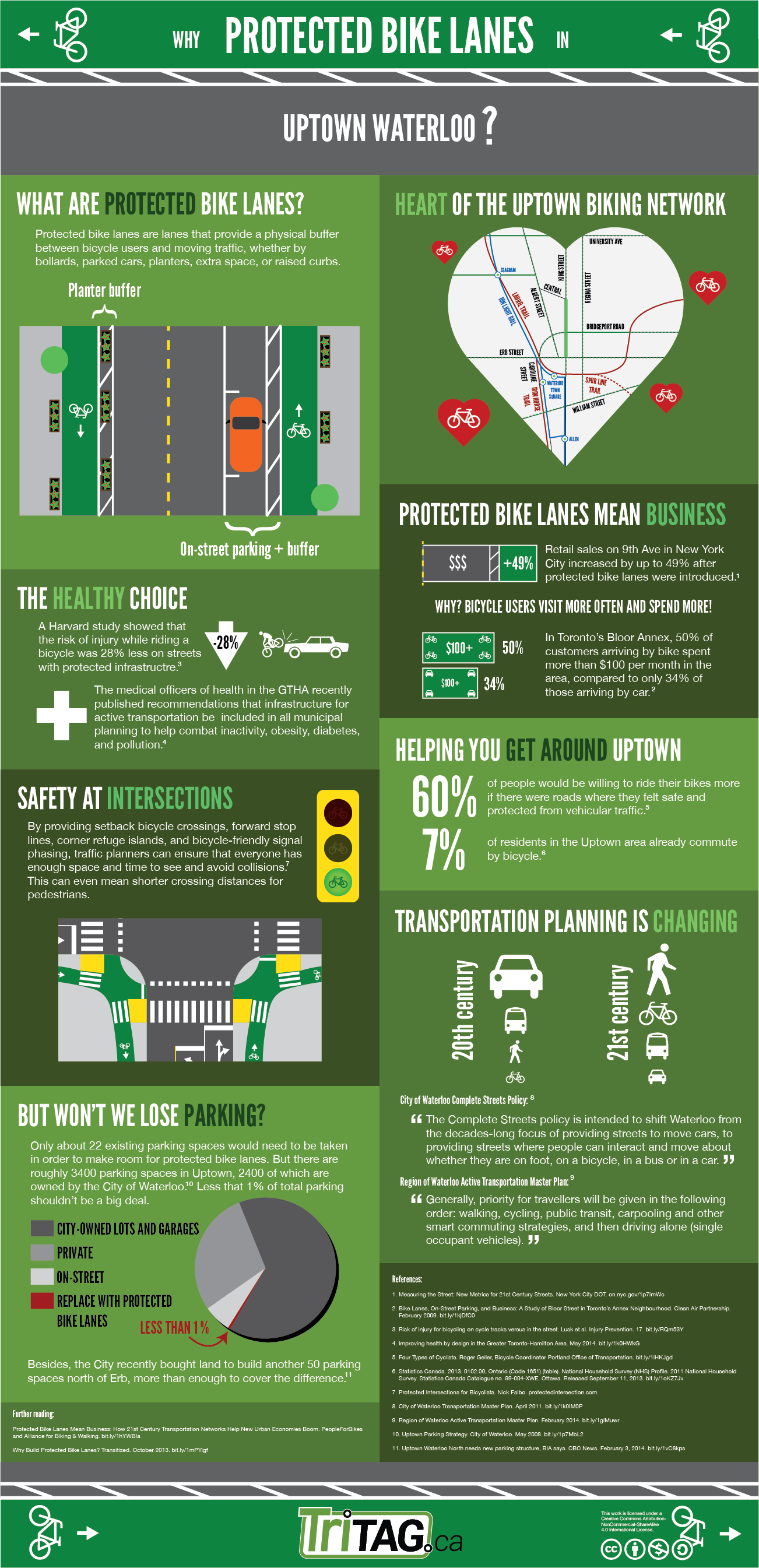
Not sold on protected bike lanes yet? Check out our infographic. Or, read on for more details on why this is the right fit for uptown.
TriTAG believes the new proposal is a vast improvement over the November 2013 plan. Whereas the old plan was presenting awkward and potentially dangerous cycling infrastructure, the protected bike lane solution for Uptown isn’t just good for cyclists, but for everyone.
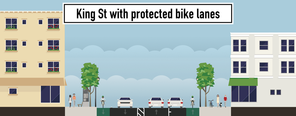
Wider sidewalks, protected bike lanes, parking and safer lanes for Uptown
The presence of protected bicycle lanes will help to attract people to uptown by bike, including many who do not cycle now, some who do bike but avoid King St, as well as the influx of thousands of new residents coming to the intensifying King St. corridor. This increase of cycling is the experience of cities like Montreal, Chicago, Philadelphia, New York and Washington DC and was the subject of a recent study that found that protected bike lanes led to ridership growth of 21 to 171 per cent. Furthermore, this trend also appears to be a boost to business along the route.
Add to all this new data showing that protected bike lanes and their intersections don’t just feel safe, they’re also very safe in practice.
King St. North will serve everyone better with protected bike lanes, pedestrian islands and turn lanes.
But ultimately, every customer of a King St. business arrives on foot whether they travel by car, bike or transit. The new proposal shines here, too. Space will allow for both wider, more welcoming sidewalks, and increased ability for pedestrians to cross King St. by slowing traffic, introducing crossing islands, and reducing crossing distances. Meanwhile, the protected bicycle lanes will get cyclists off the sidewalks and provide an extra buffer from traffic that will make the pedestrian realm even more comfortable.
Click to see TriTAG’s protect bike lane infographic for more.
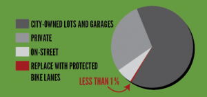
It’s unfortunate that for a few, none of this matters as much as the removal of 22 on-street parking spaces. But as we have pointed out before, this is a tiny fraction– less than 1%– of the Uptown parking supply. Furthermore, these lost spaces will be more than replaced by a new planned parking lot, with the opportunity to adjust to parking demands along side streets and with new development.
Space along King St. is precious, and we should be using it to its maximum effect. A small reduction in space for car storage gives us the chance to build an Uptown that is human-friendly, designed to safely move all road users, and truly welcoming. TriTAG believes this is a trade worth making, and we hope you agree.
Read More »