TriTAG is concerned by apparently disingenuous tactics being used in an attempt to derail plans for Waterloo Region’s first segregated bike lanes on Manitou Drive.
In August, the Regional Planning and Works Committee unanimously approved the preferred design option for the Manitou Drive improvements, which would include sidewalks and segregated bike lanes on both sides of the road. The segregated bike lanes would provide continuity between planned bike lanes to the north on Manitou Drive between Bleams and Fairway, and with bike lanes to the south on Doon Village Road. They would also help to form an on-road cycling route between the Doon Village neighbourhood, the Trans-Canada Trail, and ION rapid transit. Presently absent sidewalks would provide safe walking space and would be essential to expanding transit service to the area. Final approval of plans for Manitou Drive is scheduled for the Regional Council meeting on September 17, 2014.
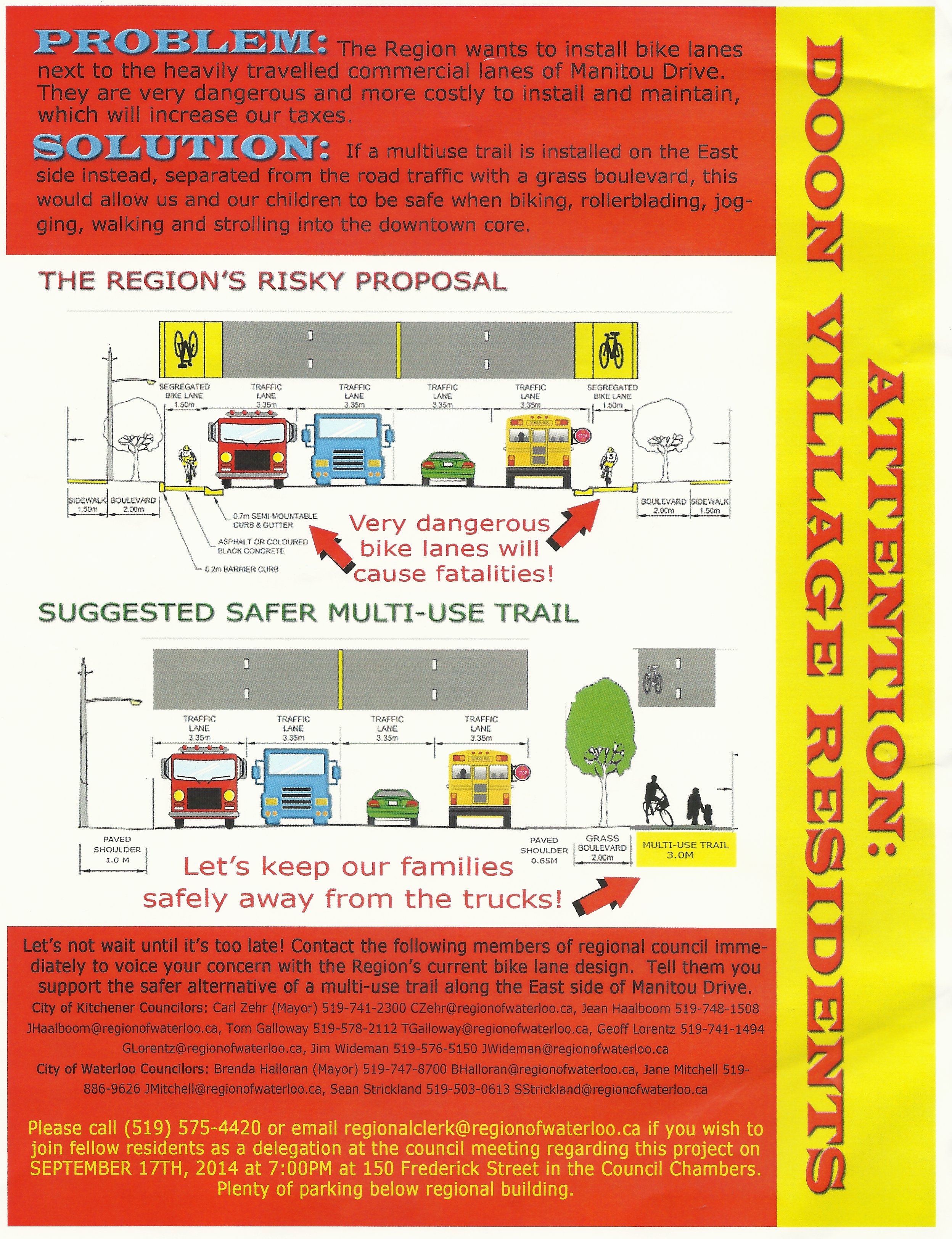
Flyers have recently appeared in the Doon Village neighbourhood, claiming that the committee-approved bike lanes would be “very dangerous” and “cause fatalities.” As an alternative, they propose no sidewalks and one multi-use trail on the east side of the road, to be shared by both pedestrians and cyclists. These flyers, which call on residents to contact Regional Council members, contain several errors and exaggerations, as we will outline below.
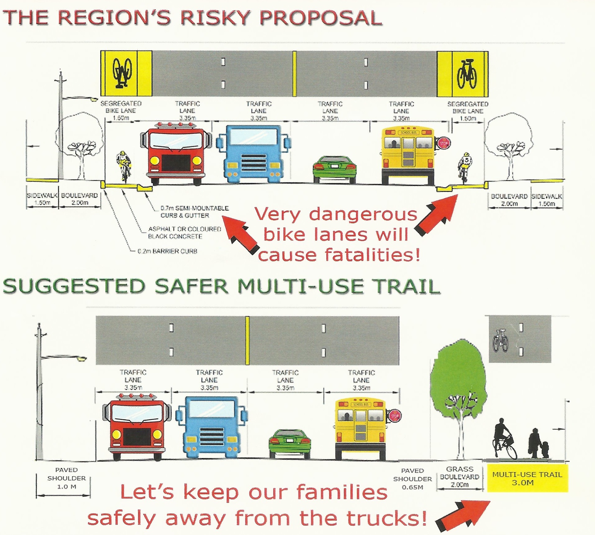
Misleading cross-section illustrations of the Manitou Drive design.
The flyers’ cross-section illustrations (above) would have you believe that bicyclists would be right alongside fast moving trucks, which would indeed be a serious concern. But when you compare the illustration of the segregated lanes to the actual design (below), you realize they’ve taken quite a few liberties. The vehicle lanes, and indeed the vehicles themselves, have all been stretched in the image so they appear to be brushing up against the bike lanes. (Interesting how the vehicles and lanes don’t appear to be as wide in the proposed alternative cross-section!)
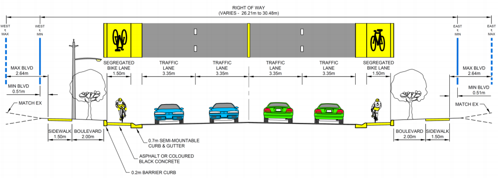
Actual cross-section design for Manitou. Note the 0.7 m buffers between bicycles and motor vehicles.
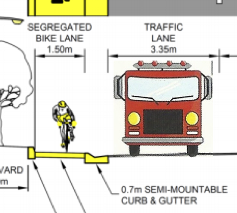
Fire truck, to-scale.
It’s also worth noting that even a vehicle as wide as a fire truck would not come close to bicyclists. We’ve attempted to render a fire truck to-scale next to a segregated bike lane (left).
The inclusion of a school bus in the cross-sections is a nice touch. The image of a school bus invokes fears for the safety of schoolchildren, who wouldn’t be on this street anyways – Manitou Drive is in an industrial area with no homes or schools along it.
The flyers call an east-side multi-use trail a “safer alternative.” The Planning and Works Committee report finds that a multi-use trail would not be safer, due to the number of driveways the trail would need to cross, creating numerous conflict points. Consequently, Active Transportation Advisory Committee has endorsed this option as its preferred alternative. The flyers also claim that the bike lanes are “more costly to install and maintain, which will increase taxes.” Installation costs for the road work costs are already covered in the Ten Year Transportation Capital Program. The report does note that bicycling facilities will lead to additional maintenance needs, but it is not clear that these costs would be greater than those spent maintaining a multi-use trail.
The flyers do not state their source, so we cannot say for certain where they originated from. However, the proposed trail design and claims that segregated lanes pose danger to cyclists echo those of a handful of business owners along the west side of Manitou Drive who have organized a petition against the sidewalks and bike lanes. These businesses do not want to have to maintain sidewalks in winter (in spite of clear desire lines for pedestrian infrastructure). Additionally, both Google Maps and aerial photography reveal that some of these businesses are accustomed to using the space the sidewalk and bike lanes would occupy to showcase vehicles. One must also wonder why this alleged concern is only being expressed now for pedestrians and bicycle users, and not before over existing Manitou Drive conditions?
TriTAG is concerned that not only is misinformation being spread about the proposed segregated bike lanes and sidewalks, but also that it might have been disseminated in order to serve private interests, for reasons entirely unrelated to public safety.
The Planning and Works Committee made the right decision in August. Let’s hope this decision isn’t derailed by dirty tricks.
The flyer is pretty silly. However, there is a good reason to prefer a bidirectional multi-use trail on the east side of Manitou Drive. I’ve taken Manitou Drive hundreds of times on my way to Cambridge. For the most part, the journey from Kitchener to Cambridge is a lovely ride along protected trails and quiet streets. It only gets unpleasant when you’re trying to get from Fairway to the wooded trails along the Grand River. The choice basically comes down to Wilson Avenue, which is long and dangerous, or Manitou Drive, which is short and dangerous. The ride down Manitou is a steep descent that ends in a blind corner where car traffic goes right and cyclists who want to go onto the trails turn left. Trying to turn left across traffic at the bottom of that hill is probably the hairiest thing that I routinely do on a bike. When there’s traffic whizzing down the hill behind me, it is truly terrifying.
Segregated bike lanes on either side wouldn’t solve the problem, would they? I presume these would be one-way bike lanes, so I’d be breaking the law if I were to descend on the east side of Manitou. A single two-way trail would be more useful, it seems to me. It would allow cyclists to safely descend the hill and turn east into the woods.
At any rate, I would love to see any kind of protected lanes on Manitou Drive and/or Wilson Avenue. Currently this part of Kitchener is woefully underserved in terms of cycling infrastructure. It’s a real shame because this area is a crucial link from central Kitchener to the wooded trails along the west bank of the Grand River.
http://grist.org/cities/when-adding-bike-lanes-actually-reduces-traffic-delays/
Mike L. – I agree about this part of Kitchener being the worst part of the ride from KW to Cambridge. A few changes have been made recently that have significantly improved the situation in my opinion.
First, the extension of Wabanaki Dr. between Wilson and Fairway is nice, low traffic, and has a (non-segregated) for about half of the way. Second, there is a curb cut and small paved path that allows a cyclist to get between the dead-end Connaught Pl. and 1st Avenue to cross under the Expressway. Previously, taking this route required sidewalk riding and negotiating a narrow unofficial path.
Mike L. – There are 2 projects for Manitou Dr. being developed now. The drawing above applies to the Homer Watson to Bleams project. Your problem area is in the Fairway to Bleams project, which will have a similar cross section, but with only 3 traffic lanes (the middle one for left turns). There will be a new bridge over Schneider Creek and it will have a trail underneath it beside the creek. So you will be able to get from the southbound bike lane on Manitou to a new trail to the right which curves around to pass under the new bridge and on to the existing valley trail. This should solve your problem. I think it’s going to be a bit steep, so make sure your brakes are good.
Evan, thanks for clearing that up. I should have read the post more closely. Yes, it’s a great idea to add pedestrian and bike paths between Bleams and Homer Watson. I’ve ridden that way when the forest trails were snowed over and it was always very dicey. As for the problem of turning onto the Schneider Creek trail when riding southbound, a left-turn lane would help a lot.